Saturday, 8 September 2018

Day 6 – We’re in Trouble!

The days have been hot and the nights cold.  Not surprising for a desert!  Each morning we’re completed pre-start checks on the vehicle and trailer.  This morning there was a problem.  Actually there were two problems and both were with the trailer.
After only one hard day of corrugations and ruts the four shock absorbers on the trailer independent suspension are stuffed!
IMG_2659
They have been beaten to pieces by the track.  Then Carlin noticed a more serious problem.  The heads on the camber bolts had sheered off.
IMG_2656
The trailer suspension was floating around loose and could fall apart if we continued.  What to do?  We’re almost exactly at the halfway point and no trailers (let alone vehicles) get recovered out here.  The cost of recovery is just too high!   We were going to have to use our initiative to solve this problem.
Being the mechanic Carlin took the lead.  He’s also much thinner and therefore more suited to getting under the trailer Smile. The other end of each bolt (there were two) had two nuts.  One to retain the bolt and the other as a “locking nut”.  We removed the outer nut and relocated the inner nut towards the end of the thread.  This enabled us to hammer the bolt back through the suspension arm and mount leaving almost 12mm of shaft sticking out.
IMG_2657
Then we used some of the 2mm stainless steel wire I purchased prior to departing just in case we experienced some type of mechanical emergency (Readers you will realise, despite appearance, I’m not totally stupid).
IMG_2658
IMG_2661
Both ends of the bolt were wired together and then tensioned.  In an effort to ensure the bolt didn’t work back out of the mounting I used my Aldi Duct Tape and wrapped the entire area.
IMG_2660
So now we have no shock absorbers and the suspension is held with 2mm wire and duct tape.  If we were going slow yesterday it will be a crawl today.  We must complete the rest of the Gunbarrel and reach Warburton on the Great Central Road in the hope we’ll be able to obtain replacement bolts.
But then things improved (but not with the suspension) when we came upon our first group of wild camels.
IMG_2596
Hit one of these with the 4x4 and you’ll know all about it.
IMG_2598
Obviously they don’t see many humans or vehicles as they were very curious.  The looks on their faces suggested they were thinking “What the hell are you doing out here?”
Camels are not native to Australia.  They were introduced, along with their Afghan handlers, to transport goods through the centre of the country in the period prior to railways and roads.  With the construction of the old Central Australian Railway to Alice Springs the camels became redundant and we released to roam the deserts.  Their number increased significantly and a small export trade for live animals to the Middle East now exists.  However most of them are simply culled as they compete for food with cattle and native animals. 
I managed to video the second group.  You may notice the large bull at the rear (with big hump) keeping his harem in line.  They don’t appear to be all that intelligent deciding to run in front of the vehicle down the track.  It took several kilometres to pass them as we couldn’t go any faster than they could run.

<filesize  5.7Mb>
Then we came upon a camper trailer where the owners either weren’t bush mechanics or they had failed to buy steel wire.
IMG_2606IMG_2608
I suspect the decal says it all…….
Thirty kilometres later we made it to Mount Beadell.


Friday, 7 September 2018

Day 5 – Halfway Across the Gunbarrel

It was quite a surprise to find the track east of Carnegie Station was reasonably well formed.  I’d been anticipating falling of the end of the earth.  However the Wiluna Shire border extends for another 100km to just beyond the Mungilli Claypan and the junction with the Eagle Highway heading north and the David Carnegie Road going south.  Of course both of them are tracks rather than roads!
Luck was on our side as the shire grader was just completing the final maintenance when we passed through this section of the Gunbarrel.  The grader operation is actually a road train.  This far away from civilization means the grader operator can’t go home at night.  Instead, his home travels behind on a trailer.  Actually the grader tows two long trailer whilst grading.  The first trailer usually holds a large diesel tank and generator whilst the second has a portacabin and toilet.  Behind the 2nd trailer was the operators ute.
With the track in such good condition we made excellent progress.  Five hundred kilometres along the Gunbarrel we reach “The Oval”.  This is a large cleared area of land which was created as a sports ground.  It’s where the Wiluna and Warburton communities used to meet to play football.
IMG_2588
Football Oval
Some Aussie with a great sense of humour had left a sign opposite the oval
IMG_2586WACA (West Australian Cricket Association)  MCG (Melbourne Cricket Ground)
It was at this point we met our first vehicle on the Gunbarrel.  A husband and wife from Perth heading in the same direction but without a trailer they were travelling much faster.
<Filesize 2.2Mb>
It was still quite early in the day so we pressed on to the next major landmark, the “Truck Wreck”
IMG_2589IMG_2592
Thirty kilometres further on and the road was still in reasonable condition.  At this point we reached the Mungilli Claypan.  There isn’t much risk in crossing the claypan provide there has been no recent rain in the area.  As we were passing through immediately prior to the period of spring rain the surface was firm.
Shire Border
Very shortly after the Mungilli Claypan the track deteriorated significantly.  Our speed dropped accordingly and we started to make very slow progress averaging 25km/h.  Approximately 550km from Wiluna we reach the Geraldton Historical Society Bore where potable water can be obtain using a hand pump.  This is also the junction with the Hunt Oil Road which heads south towards the Great Central Road.  This road was create by Hunt Oil when they were surveying this part of the Victoria Desert for petroleum.  This also marks the end of Wiluna Shire.  From this point onwards the track isn’t maintained. 
We ‘bounced, groaned, and squeaked’ our way for a further 40km to reach Everard Junction where the Gary Highway heads north to the Tanami Track.   Monique signed the visitors book whilst we stopped for a look around.
IMG_2603
The land is as flat as a pancake covered in Spinifex grass   with the odd stunted sheoak.
The track was now starting to get bone shaking rough with thousands of corrugations hammering the hell out of the suspension.  We slowly crawled on to reach Mount Everard.  OK ‘mount’ might be more than an exaggeration, but then the land is so flat that any hill gets named “mount”.  My middle name is Everard so I guess Mt Everard has some connection to me! Winking smile
 IMG_2604
There are panoramic views from the top.

This next video shows the way we have come

<Filesize 1.4Mb>

And this video shows our future direction

<Filesize 1.8Mb>

We are a long way from anywhere!

By now it was starting to get late and we needed to find a campsite.  Fortunately traffic noise wasn’t an issue and we found a suitable clearing on the north side of the track.   
IMG_2612
And the sun went down.
IMG_2619

Thursday, 6 September 2018

Day 4 – Carnegie Station

From Wiluna to Carnegie Station is 384km and I had anticipated the road to be rough but acceptable.  It turned out I was pessimistic with the road being in good condition.  There were corrugations however we found driving at 90kmh allowed the 4x4 and trailer to skip over the tops giving a smooth ride.
IMG_2554
I used our new 4K Action Camera to take video footage during the trip.  However 4K video is rather large and I’ve therefore reduced the size of the video clips to Standard Definition where they are posted on the blog.  I’ll also list the size of the clip below the video so readers can decided whether they want to use some of their data allowance by streaming it.  The audio should have been removed (I hope).   Obviously I’m a total novice when it comes to recording video.  And the first thing I have noticed is Open Live Writer will not allow me to embed a video into the post.  It has to be done directly into Blogger.

<file size is 3.2Mb>

Carnegie Map
At Mingol Camp we stopped for 30 minutes to change drivers, rest the engine and have a brief look around.  This is a well known camping location for people travelling the Gunbarrel.  This is also the location of Johnson Waters and I’d read accounts of some people taking a swim.


<file size is 6.1Mb>
Carnegie Station was a further hour east.  This is the last piece of civilization we will see until we reach Warburton on the Great Central Road.


<file size is 3.5Mb>
There are usually only three people living here throughout much of the year.  However they were in the middle of the annual muster when we arrived and numbers had swollen to 20.  Brendan, one of the young friendly Jackaroos offered to fill the 4x4 with diesel.  At $2.50 a litre I thought it might be the most expensive fuel we’d purchase during the trip.  Brendan had the same complexion as Donald Trump, white around the eyes and a deep orange face.  In Brendan’s case it was from wearing goggles to protect his eyes when riding a speeding quad bike whilst mustering the cattle.  His orange was a combination of wind and the earth. 
I asked him how long he’d been on the station? “Two years!”  Before that he’d worked on a couple of stations further north in the Pilbara. I was amused to hear he was originally from Victoria.  Australian cowboys are called Jackaroos and cowgirls are called Jillaroos.
IMG_2817
The station covers more than one million acres and carries approximately 3500 head of breeding cattle.  That’s approximately 285 acres per beast.  Mustering has been made slightly easier with the sinking of numerous bores driven by windmills.  Towards the end of winter the cattle tend to congregate near water.  The annual rainfall is usually in early spring.
I was slightly surprised to hear the station owners actually live south of Perth visiting once a month to bring supplies.
With plenty of daylight remaining we decided to press on travelling another 50km east before deciding to camp beside the road.  That evening I decided to make my first attempt a night photography.
IMG_2570
Obviously I’m going to need considerably more practice! 

Wednesday, 5 September 2018

The Gunbarrel Highway – Brief History


The Gunbarrel Highway was the first road built as part of Australia's role in the British weapons research facility called Woomera in South Australia. The area of land designated between Woomera and 80 Mile Beach near Port Hedland in West Australia was chosen as the most suitable area in the world for a rocket range, but it was an uninhabited desert waste-land in the most remote part of Australia.  Well not actually uninhabited because nomadic aborigines still wandered around this vast area.

This weapons research project did not just involve the launching of rockets into waste-land, but complex missile tracking instruments had to be placed in position throughout this vast region and so a massive ground survey was required to determine the earth's shape and optimum locations for the instruments.


The first task was to construct a road running east-west across the centre of Australia to provide a major service access for the construction of all other linking roads. The Gunbarrel Highway was the first of the Len Beadell roads and so is a very historical journey for people taking the trip today.

Len Beadell was an army surveyor who was given the task of completing the survey for the project.  Len admitted he was " a surveyor who liked to draw neat lines on maps", so he decided to site his roads in areas where long straight tracks could be built. It was Len himself, who light-heartedly named his road gang the "Gunbarrel Highway Construction Party". This was done for distance, fuel and maintenance efficiencies for both his construction team and future users. 

The survey method Len Beadell employed was to “bush bash” in his Land Rover using a magnetic compass and the vehicle odometer.  When he had found a suitable route he’d stand on top of the Land Rover and either flash a mirror of fire a flare to Doug Stoneham who was operating the D8 bulldozer.  Doug would cut a straight path to Len checking his alignment by looking back at the cut he’d made.   Scotty Boord would follow the bulldozer in the grader and form the road. The grader was followed by Willy Appleton who cleared the track of any remaining sticks, roots or stones.

The other members of the construction team were Rec Flatman, mechanic Paul Christensen, cook and Bill Lloyd, supply driver.

The road was constructed in four stages commencing in 1955 and finishing in 1958.  At the conclusion of the rocket tests maintenance of the eastern end of the road ceased and today only hardy adventurers attempt the four day crossing.  I guess that makes us hardy adventurers! Smile

Tuesday, 4 September 2018

Day 3–Meekatharra to Wiluna and the Gunbarrel Highway

After a quiet night we were up at dawn preparing for another long day.  From this point we leave the bitumen and will be travelling on unsealed roads.  The distance today would be approximately 600km, so shorter than yesterday.  However being off the bitumen would slow us down.

The first part of the journey was on the Goldfields Highway to Wiluna (183km).  This road is part of the State Highway network and was well maintained.  Beyond Wiluna the road is maintained by Wiluna Shire as far as their border with the Aboriginal Lands.  It’s very dry around here although the country will ‘green up’ in a couple of months when the spring rain arrives.  Then it will be another 10-11 months before the vegetation gets another drink.

Wiluna is on the western edge of the central Australian deserts.  Gold was discovered here in 1896 and within a few years the town had a population of 9000.  The discovery of gold and the subsequent issue of pastoral leases forced the traditional aboriginal people off their lands and into Wiluna were the missionaries set about saving them.  Unfortunately this forced relocation has had the opposite affect and Wiluna is now beset with social problems.  Alcoholism and domestic violence are major issues.  The town has a large police station with what appears to be a sizeable number of officers.

Apart from servicing the aboriginal community, the surrounding cattle stations and local mines Wiluna’s major purpose is to provide supplies to passing travellers traversing the Canning Stock route to the north or the Gunbarrel Highway to the east.

IMG_2550

Steel silhouettes representing Wiluna’s history 

IMG_2551

Wiluna’s supermarket and service station.  It’s built like Fort Knox with heavy steel door and grills over every access point.  Fuel had to be pre-purchased by credit card inserted into a kiosk.  Obviously the town suffers from a high level of crime.  Wiluna is the local aboriginal word for penis.  However I can think of another part of the anatomy which is more appropriate!

After topping up the fuel tank we headed to the eastern side of the town and the official start of the Gunbarrel Highway

IMG_2552

The timing for our trip was almost perfect as the Shire graders were just completing their annual maintenance of the road.  This part of the highway was smooth and wide.  However we knew that would change.

IMG_2554

Our journey will take us through the Little Sandy Desert and then the Gibson and Great Victoria Deserts.

Monday, 3 September 2018

Day 2 Perth to Meekatharra

An early departure as we have a long day ahead.  It’s 777km from Perth to Meekatharra on National Highway 95.  I opted for a Sunday departure in the hope we would encounter minimal road trains during the journey.  Highway 95 is the man inland route north and being the shortest route is very busy.  There are no rail lines to northern West Australia resulting in 90% of the freight being transported by road train.  This far south they are limited to a maximum length of 100ft and usually consist of a prime mover towing three long trailers.  Further north you can encounter roads trains with a 4th or 5th trailer.

The trip will take us via New Norcia, Payne’s Find, Mount Magnet and finally Meekatharra.  The maximum towing speed in West Australia is 100kmh and I’d calculated we would be driving for 9-10 hours changing drivers on the hour.  This day we will be on bitumen, but that will change once we reach Meekathara.

Two hours north of Perth is New Norcia.  Until today this is the furthest north I travelled by road in West Australia.    New Norcia is the only monastic town in Australia.  In 1846 two Spanish Benedictine monks arrived to establish a mission to convert the local Aborigines.  The abbey continues to operate with 11 monks living in the monastery.  

This part of West Australia is the northern wheatbelt.  From this point onwards the flora starts to change.  Grain farming is replaced by dry mulga bush and salt pans.  We start to enter the western goldfield region.

Four hours later we reached Paynes Find where we needed to refuel.  After the price of diesel in Perth the cost at Paynes Find came as a shock.  However we knew from this point onwards the price would continue to rise, therefore the plan was to regularly top-up the tank and save the diesel in our jerricans from the most expensive part of the journey. 

In its heyday there was a town but all that’s left is a roadhouse and tired looking motel units.

IMG_2541

The roadhouse

IMG_2543

A few scattered old buildings

IMG_2544 

The motel units surrounded by lush green grass Smile

Thomas Payne discovered gold here in 1911 and the original gold battery continues to operate.   But mostly for passing tourists!  Another major attraction here are the seasonal wildflowers.

We press on to Mount Magnet noticing more signs of mining.  Explorer Robert Austin named the prominent hill Mount Magnet after it affected the readings on his compass.  The hill has a very high iron content.   Gold continues to be mined in the surrounding area. 

Another three hours of driving had us reach Meekatharra.  For the last 30km we travelled adjacent to the perway of the now abandoned Northern Railway.  The line was built during the last 10 years of the 19th century to service the goldfields.  It was extended east in 1909 to reach Wiluna.  The line was closed in the early 1970’s

Meekatharra is an Aboriginal word meaning “Little Water”.  For a brief period the local area experienced a gold rush but this rapidly died.  Today Meekatharra is a service centre for the surrounding cattle stations and mines.

IMG_2545IMG_2546

With the 4x4 refuelled <ouch> we made an unsuccessful search for a food outlet and eventually gave up.  In the months prior to departing I’d carefully examined Meekatharra in Google Earth and thought I’d identified a potential free camping area just east of the town on the road to Wiluna.  This proved to be correct and was where we spent our first night.  

IMG_2547

Carlin cooked dinner <obviously he’d been briefed on my culinary skills by his grandmother> whilst Monique opted to dig the latrine and wash up.

IMG_2548

I <of course> employed my supervisory management skills!

We used the ‘Kelly Kettle’ for the first time and I was impressed with it’s performance.  Hot water was rapidly produced using a combination of dead leaves and dry twigs.

IMG_2549

My one man stretcher tent was quickly erected; meanwhile Carlin and Monique had their first real experience of erecting the rooftop tent on the trailer.  We were in bed just after dusk knowing we’d have to rise at dawn for another early start. 

Sunday, 2 September 2018

Day 1 – Preparation

Dear reader, if you are reading this then it will be obvious we survived the trip…. and it proved to be the adventure we’d anticipated!  I plan to update the blog by writing about each day over the next two weeks.   Hopefully you will find it interesting.

Before attempting a trip like this you need to be thoroughly prepared.  If something were to go wrong with the vehicle or trailer there’d be no recovery as the cost would be just too high.  From a people perspective injury and illness would be the major concerns.  For example; Australia does have the six most deadly snakes in the world!

I’d been planning the trip whilst we were living on Waiouru and with our return to Australia it meant moving into the preparation stage.  Buying a suitable 4x4 was an important decision and I think I got it right.  The Isuzu was slightly modified with my installation of a secondary diesel fuel filter, oil catch can, two way radio, trailer wiring and rear fridge.  I also changed the stock wheels from a 18” alloy rim to a 16” steel rim with larger diameter tyres that had an off-road tread.  Our Chinese trailer hadn’t arrived in time for the trip, however the dealer kindly loaned me one of theirs.  Whilst I was disappointed about not being able to fit-out and use our trailer, using theirs might provide an opportunity to test the basic design and identify what I might do differently.

Another step was to assemble all the equipment.  Four jerricans for additional diesel and containers for a further 100 litres of water to supplement the 80 litres carried in the two integral trailer tanks.  I produced an itinerary calculating distances and also estimated fuel consumption along with a food plan (meals) which enabled Jan to purchase the necessary food.  The food was a mixture of frozen, dry and canned.

Obviously safety was a major consideration.  Initially I decided to hire an emergency beacon which could be activated if something serious was to go wrong.  However that meant I wouldn’t be able to explain the nature of the problem and I therefore opted to hire a satellite phone at a higher rate.  The satellite phone would be returned when we reached Ayers Rock.  Being isolated for several days also meant I needed to compile a comprehensive first aid kit.

The Isuzu 4x4 was given a thorough service and a final check to ensure everything was tight (check all the bolts) and then we collected the trailer.  It quickly became apparent we would need to make temporary modifications to the trailer in order to ensure everything remained secure during the trip.

IMG_2533

Carlin carefully stows the equipment

IMG_2534IMG_2537

My food storage boxes were a success

IMG_2538

All the weight on the top of the trailer meant the gas struts couldn’t hold the lid load.  We resorted to using the pick handle as a prop.

Our first day will be a long one travelling north from Perth to Meekatharra.  All of it will be on bitumen.   

Saturday, 11 August 2018

Last Post…….. for 3 weeks!

A frenetic day purchasing last minute items and packing both the trailer and 4x4.  We depart at dawn tomorrow on our three week odyssey around Western Australia and the southern part of the Northern Territory.  There will be no internet coverage and therefore no blog posts until my return.  Hopefully there will be plenty of interesting things to write about.

Already I can see I’ll be busy on my return.  A hire r trailer to unpack, clean and return.  Plus 3 weeks of other blogs to catch up.

Au revoir!

Friday, 10 August 2018

I’ve just been too busy

It wasn’t until a very good friend phoned to ask if I was OK that I realised time had gotten away on me and it had been a week since the last blog post.  It’s not a case of nothing happening or me being lazy but I’ve just been so busy attempting to finish the house and preparing for the outback trip.

The new timber floor is now down in the lounge room.  This is the last of the new flooring for the near future.

IMG_2531

IMG_2532

Only a couple of minor jobs left in the kitchen and it will be done.


Our eldest grandson and his girlfriend arrived on Wednesday and we’ve been spending much of the time preparing the trailer for the big trip. 

We’ve been into central Perth to collect the rental satellite phone.  There is no plan to make calls on it (expensive) but rather use it should an emergency arise (snake bite, vehicle breakdown, hit a camel, etc)

Our camper trailer has just reached the port and is waiting customs clearance so we accepted the dealer’s offer of a loan trailer.  That bought its own problems because we need to fit equipment into the trailer but obviously this won’t be permanent.  It also means no drilling holes, etc.

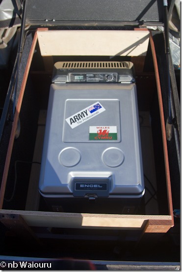
Carlin and I have made a temporary frame to hold the Engle freezer in the large bin on the trailer drawbar.  It needed to be secured as we are anticipating the trailer will be bouncing and vibrating for three weeks.

IMG_2524

The temporary mounting takes up all of the bin.  I think I can recover some of this lost space when I fit the freezer into our trailer.    More thinking required.

The roof top tend and awning needed to be seasoned and then dried.  We also needed to check it for damage.

IMG_2527

Carlin and Monique will sleep in the roof top tent whilst I will sleep in my stretcher tent under the awning.  The ‘Batwing’ awning wraps around the opposite side of the trailer and the rear.

IMG_2528

Much of today was spent manufacturing temporary framing to secure the 2nd spare wheel inside the trailer tub.  I’m already thinking this 2nd spare will fit under our own trailer.  I’ll also need to modify the trailer rear door as it is currently only designed to open 90deg.  I’ll need at least 150deg.

Tomorrow we will do a test pack with a planned departure date of Sunday 12 August.  I’m aiming for Sunday as that is the day we are least likely to encounter ‘road trains’.

Saturday, 4 August 2018

Another one almost completed

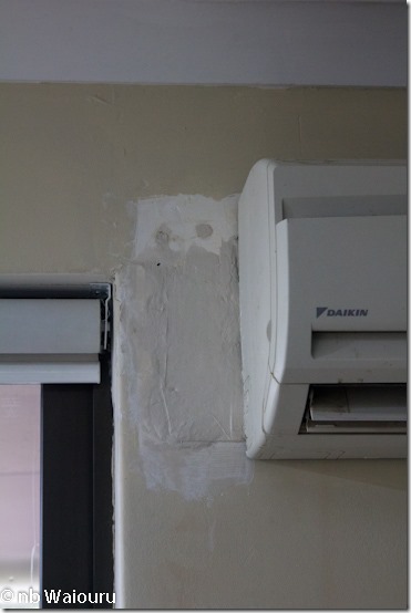
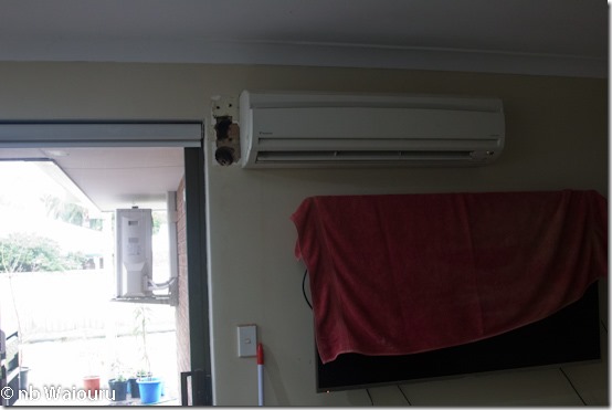
The external half of the split air conditioning unit has been moved.  But not without a little extra work.  I wanted the pipework and wiring concealed in the cavity between in the inner and out walls of the house.  To achieve this the internal unit had to be moved 150mm to the right and a new hole cut through the wall.  This left the original holes exposed.

IMG_2521

You might have noticed the external half of the unit is now up on the wall in the above photo.

A common way to repair these holes would be to inject expanding foam into the hole.  But that costs money!  My solution has been to screw up several sheets of newspaper into balls and force them into the holes before plastering over.

IMG_2522

It’s only the first coat of plaster and several more will probably be required.  Yes…. this is a part of the wall recently painted. Sad smile 

I’ve also been busy in the front yard cutting up the trunk of the gumtree with the small electric chainsaw.  The pieces have to be small enough to fit into the “wheelie bin”.

Local blog reader ‘Ken’ and his wife Elaine visited today.  They head to the UK early next week with a three week canal cruise on the agenda.  Lucky them!  With the UK currently experiencing a heatwave they won’t need to acclimatize. Winking smile

Thursday, 2 August 2018

No heatwave here

After reading about the ultra hot weather in the UK during the past few weeks it was interesting to note the difference on the other side of the world.

Last night we experienced yet more strong wind gusts and heavy rain.  I think this was the fourth storm in the last 10 days.  The grass turned white with some of the locals claiming they were experiencing snow.  It doesn’t snow in Perth, Western Australia.  Yes it was hail!

When it comes to stormwater drainage Perth is very similar to Riyadh.  There’s almost no stormwater drainage system as 90% of Perth is built on sand.  Any stormwater is either directly absorbed into the ground or diverted to local soak pits.  Of course there isn’t much in the way of annual rainfall anyway.

We arrived back in Australia at the end of May 2017 just in time for winter.  That winter didn’t appear to be very cold.  This winter is about the same but we are certainly feeling colder.  I guess our blood has thinned.  Mine has….. the cardiologist placed me on blood thinning medication. Smile

I can envisage next winter we will be keeping warm by running the reverse cycle air-conditioner on our free solar electricity.

Have I previously mentioned removing the third gumtree in the front yard.  We had the first two removed professionally at $1000 a tree.  I decided to save money and remove the third myself.  Its taken weeks, but slowly I’ve cut the tree back to the main trunk disposing the cuttings into the weekly rubbish collection.

With just the trunk left I started digging a trench around the base sawing through all the major lateral roots as I went.  Digging was reasonably easy (sand) however the task then became complex when I identified the gas main, electrical main, data, telephone cables and ground reticulation pipes all ran under the tree.  The service that worried me the most was the gas.  Once I had dug down to a level where all the pipes and cables were exposed either side of the root system I used the garden hose and water to wash the sand out from under the tree.  It’s a gumtree which I hoped would mean there wasn’t a vertical tap root.  Of course the washed out sand filled the trench which meant several cycles of washing and digging.  I then decided to take a break, which proved to be rather fortuitous as the tree fell over in the hole shortly after I’d left.

Now I need to cut the trunk into smaller rubbish bin size pieces before filling in the hole.

IMG_2518IMG_2519

Maybe I could find employment with Fountains.  I rather like the idea of operating a ride on mower!

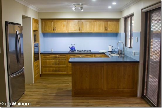
Meanwhile the glass splashbacks have been installed in the kitchen.  When I fitted the splashbacks in Waiouru I used Sikaflex.  These installers used silicon sealer. 

IMG_2520

Is that eggshell blue or baby powder blue?

I’m not in favour of using silicon sealer, unless the plan is to remove whatever it’s holding at some future date.  Silicon sealer tends to degrade and fail over time.  However the installers informed me they had to use silicon as it was a ‘neutral’ product.  If they used Sikaflex it would ‘eat’ the paint off the reverse side of the glass.  That’s when I realised they painted to colour on the glass whereas the colour was baked on the reverse when I fitted the splashbacks in Waiouru.

Just a few minor jobs and the kitchen/pantry project will be finished.  The air-con man arrives tomorrow to move the exterior half of the unit.  Then the new French doors can be fitted.